Kirkintilloch
Note: this audio piece contains reference to death and long term illness that might be upsetting to some listeners.
The stories
This page contains audio please turn your volume on. This sound piece includes stories provided by Marie Curie Hospice and music from Kirkintilloch Kelvin Brass Band and Kirkintilloch Male Voice Choir.
The walk
Distance: 2.81km
Total Ascent: 14m
Estimated Time: 50mins
A flat circular route including residential streets and footpaths around Merkland Nature Reserve.
Online Route available here


Start here!

1.
Turn left out of Hillhead Community Centre onto Meiklehill Road. At the end of the road turn left onto Newdyke Road and then right onto Langmuir Road.
2.

Follow Langmuir Road until you get to the shopping precinct and then turn right down Merkland Drive.

4.
Follow the footpath, then take the left at the first fork.
When the path reaches a metal brige on your left, take the path to the right.
3.

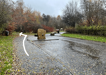
Turn right into the entrace of Merkland Nature Reserve and take the footpath to the left of the large Merkland Nature Reserve sculpture.

5.
Stay on the main footpath until it gets to a fork (pictured). Take the right footpath and then immediately bear left.
6.

Follow the footpath back and turn left onto Merkland Drive.
Then take the first right onto Woodstock Avenue and follow the road as it bears right around the Merkland sports pitches. Keep following right, turning onto Newdyke Road.
7.

Turn left onto Highfield Road and then take the next right onto Highfield Avenue. This will lead you straight back to the Hillhead Community Centre.
